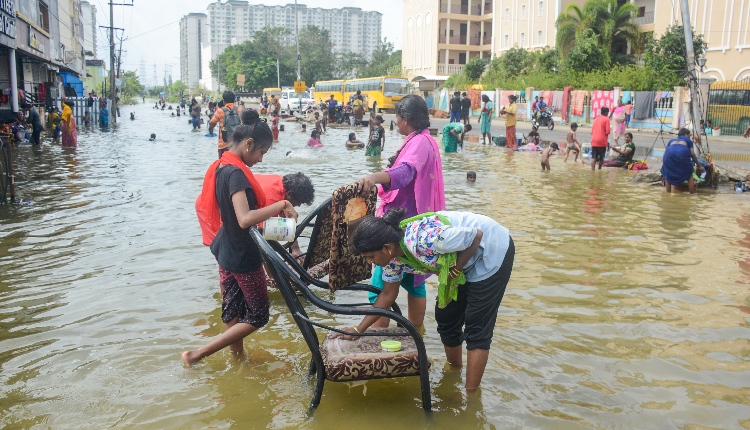
Chennai: Heavy rain continued in Chennai and surrounding districts in Tamil Nadu for the second consecutive day, marking the arrival of the northeast monsoon.
Residential areas in Anna Nagar West, Kolathur, Pammal, Perambur, and other parts of the state capital are submerged under knee-deep water.
Traffic congestion was reported in many parts of Chengalpattu, Kancheepuram, and Tiruvallur districts.
The Regional Meteorological Centre (RMC) stated on Wednesday: “It is likely to move west-northwestwards and cross the north Tamil Nadu-south Andhra Pradesh coasts between Puducherry and Nellore, close to Chennai, during the early morning of October 17 as a depression.”
The RMC, Chennai, has also forecast heavy to very heavy rainfall for 12 districts in the northern parts and the delta region.
The weather department said that rain would shift to other northern districts, including Ranipet and Vellore, by Thursday.
Chennai and its neighbouring districts may also experience heavy rainfall on Thursday, according to the weather department.
Winds with speeds reaching up to 60 kmph are likely over the southwest and adjoining west-central Bay of Bengal.
The Tamil Nadu State Disaster Response Force (SDRF) and National Disaster Response Force (NDRF) are on standby in 26 locations across Chennai, Kancheepuram, Chengalpattu, and Tiruvallur districts.
The Tamil Nadu government stated that 219 boats are ready for deployment for rain-related tasks in Chennai and other parts of the state.
It is worth noting that the monsoon was expected to set in Tamil Nadu on October 20, five days earlier than its typical onset, which usually occurs either nine days before or after the expected date.
The RMC has reported that a well-marked low-pressure area has intensified into a depression over the southwest Bay of Bengal, currently located about 490 km southeast of Chennai.
It is expected to cross the north Tamil Nadu and south Andhra Pradesh coasts between Puducherry and Nellore, near Chennai, in the early hours of Thursday.
(IANS)


