


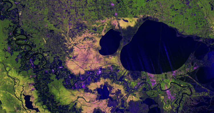
Washington: A high-resolution radar image from the US–India NISAR Earth-observing satellite has captured the Mississippi River Delta region in southeastern Louisiana, revealing fine-scale details of urban areas, wetlands, forests, and farmland across one of the United States’ most complex landscapes, NASA said.
The image was taken on November 29, 2025, by NISAR’s L-band synthetic aperture radar instrument. It shows New Orleans, the Mississippi River, Lake Pontchartrain, and surrounding ecosystems using radar signals that reflect differently depending on surface type and structure.
NISAR is a joint mission of NASA and the Indian Space Research Organisation, reflecting long-standing US–India cooperation in Earth science and satellite research.
The image resolution is sharp enough to clearly identify the Lake Pontchartrain Causeway, visible just right of center. The twin bridges stretch nearly 24 miles, or 39 kilometers, making them the world’s longest continuous bridge over water.
The Mississippi River winds across the image from Baton Rouge in the upper left toward New Orleans in the lower right. Bright green areas west of the river indicate healthy forests, where dense vegetation causes the radar’s microwaves to scatter in multiple directions before returning to the satellite.
In contrast, the Maurepas Swamp, west of Lake Pontchartrain and Lake Maurepas, appears mottled with yellow and magenta tones. These colors indicate thinning tree populations in the wetland forest ecosystem, which alters how radar signals are reflected.
On both sides of the Mississippi, parcels of farmland appear in varying shapes and brightness. Darker areas suggest fallow fields, while bright magenta patches indicate the presence of tall plants, such as crops.
The image also demonstrates the technical capability of NISAR’s radar systems. The L-band instrument uses a 9-inch, or 24-centimeter, wavelength that allows signals to penetrate forest canopies and measure soil moisture and land movement down to fractions of an inch. This information is critical for studying earthquakes, landslides, and volcanic activity.
NISAR also carries an S-band radar provided by the Indian Space Research Organisation’s Space Applications Centre. Using a shorter 4-inch, or 10-centimeter, wavelength, it is more sensitive to small vegetation and is well suited for monitoring agriculture and grasslands.
Launched in July 2025, NISAR is designed to collect global data to help scientists better understand changes in Earth’s surface, ice, and ecosystems. Its rapid coverage is expected to support disaster response by providing before-and-after observations in short time frames.
(IANS)


