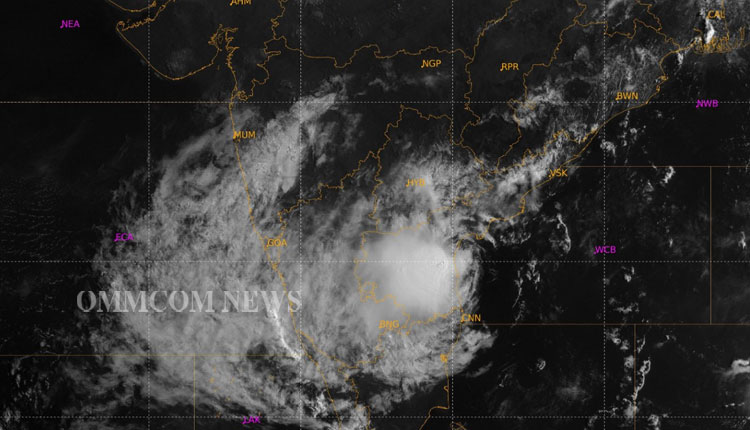
New Delhi: Right from the day a Low Pressure Area had formed near Andaman and Nicobar Islands last week, the India Meteorological Department (IMD) had been predicting its track towards northwestwards and also intensity, which included its possible skirting the Andhra Pradesh-Odisha coast and then re-curving towards north-northeast.
Even on Wednesday morning, when the Cyclone was losing steam and IMD had predicted that it will weaken into Deep Depression (a system that brings in heavy rainfall), it had said: “It is very likely to move nearly northwards for the next few hours and re-curve slowly north-northeastwards along Narsapur, Yanam, Kakinada, Tuni and Visakhapatnam coasts during noon to evening on Wednesday and emerge into west-central Bay of Bengal off north Andhra Pradesh coasts by tonight. It is likely to weaken gradually into a Depression by Thursday morning.”
Asked why the intensity prediction and the track forecast went wrong, Ananda Kumar Das, senior scientist with the Regional Specialised Meteorological Centre (RSMC) agreed that the forecast did not turn out to be correct in reality and said there were four important reasons for it. “First, the system came close to the coast and had land interaction. Second, once it was closer to the coast, it encountered low sea surface temperatures (SST) and Ocean Heat Content (OCH),” Das said.
Asked if low SST was not expected when the earlier forecast was made, Das said, “We did not expect the system to come so close to the coast.”
Then, third, as it came closer to the coast, there was dry air incursion from the land and finally, for the system to re-curve, there was no steering as there was no system column because of weakness, meaning, the vertical length of the system was very less.
Meanwhile, the system had weakened as a Depression as it crossed the Andhra Pradesh coast between Machilipatnam and Narsapur on Wednesday night and by Thursday morning, further weakened into a Well Marked Low Pressure Area (WM LPA) at 8.30 a.m. It lay to the west of Machilipatnam and is likely to fizzle out into a Low Pressure Area through the day.
Earlier in March, a Low Pressure Area had generated from near the Andaman and Nicobar Islands and was headed towards Bangladesh and Northeast of India as a cyclone. However, it did not materialise into a cyclone as the intensity fizzled out because the system encountered land interaction as the outer/fringe elements had touched the Myanmar coast, the IMD had then reasoned.
(IANS)


