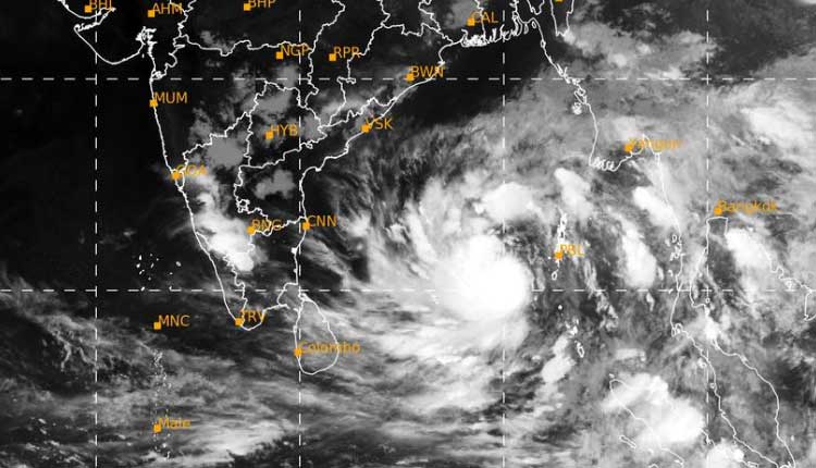
Bhubaneswar: The depression over Southeast Bay of Bengal and adjoining Andaman Sea moved northwestwards with a speed of 20 kmph and concentrated into a deep depression and lay centered at 5.30 PM today over southeast Bay of Bengal near latitude 10.2°N and longitude 90.5°E, about 280 km west-northwest of Car Nicobar (Nicobar Islands), 290 km southwest of Port Blair (Andaman Islands), 1140 km southeast of Visakhapatnam (Andhra Pradesh) and 1180 km south-southeast of Puri (Odisha), according to the Special Bulletin of India Meteorological Department’s (IMD’s) Meteorological Centre, Bhubaneswar.
The deep depression is very likely to move northwestwards and intensify into a Cyclonic Storm over southeast Bay of Bengal in the morning of May 8 and into a severe cyclonic storm over east central Bay of Bengal by May 8 evening.
It is very likely to continue to move northwestwards till May 10 evening and reach westcentral and adjoining northwest Bay of Bengal off north Andhra Pradesh and Odisha coasts.
Thereafter, it is very likely to recurve north-northeastwards and move towards northwest Bay of Bengal off Odisha coast.
Under its impact light to moderate rainfall is very likely to commence from May 10 evening at many places over the districts of coastal Odisha and heavy rainfall (7 -11cm) is very likely to occur at one or two places over the districts of Gajapati, Ganjam, and Puri.
Similarly, on May 11 light to moderate rainfall is very likely to occur at many places over the districts of coastal Odisha and heavy rainfall (7-11cm) is very likely to occur at one or two places over the districts of Ganjam, Khordha, Puri, Jagatsinghpur and Cuttack.
The IMD has warned that gale wind is likely to prevail with speed reaching 105-115 kmph gusting to 125 kmph over central parts of Bay of Bengal on May 9, speed reaching 95-105 kmph gusting to 115 kmph around the system center over westcentral and adjoining northwest Bay of Bengal on May 10, speed reaching 80-90 kmph gusting to 100 kmph over northwest and adjoining westcentral Bay of Bengal on May 11 and speed reaching 60-70 kmph gusting to 80 kmph over northwest Bay of Bengal on May 12.
Squally wind speed reaching 40-50 kmph gusting to 60 kmph is likely along and off Odisha coast on May 11 and 12.
Besides, the IMD has said that sea condition is likely to become high to very high over central parts of Bay of Bengal on May 9, become high to very high over westcentral & adjoining northwest and eastcentral Bay of Bengal on May 10, and become high to very high over northwest and adjoining westcentral Bay of Bengal on May 11 and become high to very high over northwest Bay of Bengal on 12th May.
Further, fishermen have been advised not to venture into the deep sea area over the central parts of Bay of Bengal on May 9 and 10 and over the northwest Bay of Bengal from May 10 to 12.
Fishermen who are out at sea have been advised to return to coast by the morning of May 10 and advised not to venture into sea along and off Odisha coast from May 11 till further notice.


