


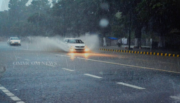
Bhubaneswar: The India Meteorological Department (IMD) has issued orange and yellow warnings for numerous Odisha districts, predicting thunderstorms, lightning, and heavy rainfall over the next five days.
Here’s a breakdown of the forecast:
Day 1 (Valid until 08:30 IST, May 29): Thunderstorm with lightning with gusty surface wind speed reaching 40-50 kmph and heavy to very heavy rainfall are very likely to occur at one or two places over the districts of Jagatsinghpur, Kendrapara, Cuttack, Jajpur. These districts have been issued orange warnings.
Heavy rainfall with gusty surface wind speed reaching 40-50 kmph is very likely to occur at one or two places over the districts of Puri, Khurda, Mayurbhanj, Balasore, Bhadrak, Koraput, Malkangiri, Kalahandi, Kandhamal, Rayagada, Gajapati, Bargarh, Nuapada, Sonepur, Sambalpur, Jharsuguda, Sundargarh, Nabarangapur and Boudh. These districts have been issued yellow alerts.
Additionally, thunderstorms with lightning with surface wind speed reaching 40-50 kmph are very likely to occur in the afternoon/evening hours at one or two places over the districts of Ganjam, Angul, Deogarh, Keonjhar, Dhenkanal, Balangir, and Nayagarh.
Day 2 (Valid from 08:30 IST, May 29 to 08:30 IST, May 30): Thunderstorm with lightning with gusty surface wind speed reaching 50-60 kmph and heavy to very heavy rainfall are very likely to occur at one or two places over the districts of Jagatsinghpur, Puri, Cuttack, Rayagada, Koraput. These districts have been issued orange warnings.
Besides, thunderstorms with lightning with gusty surface wind speed reaching 40-50 kmph and heavy rainfall are very likely to occur at one or two places over the districts of Khurda, Keonjhar, Dhenkanal, Nayagarh, Ganjam, Nabarangapur, Mayurbhanj, Balasore, Bhadrak, Malkangiri, Kalahandi, Kandhamal, Gajapati, Kendrapara, and Jajpur. These districts are under yellow alert.
That apart, thunderstorms with lightning, with surface wind speed reaching 40-50 kmph, are very likely to occur in the afternoon/evening hours at one or two places over the districts of Sonepur, Sambalpur, Jharsuguda, Sundargarh, Angul, Deogarh, Balangir, Boudh, Bargarh and Nuapada.
Day 3 (Valid from 08:30 IST, May 30 to 08:30 IST, May 31): Thunderstorm with lightning with gusty surface wind speed reaching 50-60 kmph and heavy to very heavy rainfall are very likely to occur at one or two places over the districts of Mayurbhanj, Balasore, Bhadrak, and Kendrapara. These districts are under orange alert.
Thunderstorms with lightning with gusty surface wind speeds reaching 50-60 kmph, and heavy rainfall are very likely to occur at one or two places over the districts of Keonjhar, Dhenkanal, Nabarangapur, Malkangiri, Kalahandi, Kandhamal, Gajapati, Jajpur, Sundargarh, Angul, Cuttack, Jagatsinghpur, Rayagada, and Koraput.
That apart, thunderstorms with lightning with surface wind speed reaching 40-50 kmph are very likely to occur in the afternoon/evening hours at one or two places over the districts of Nuapada, Balangir, Bargarh, Jharsuguda, Sambalpur, Sonepur, Deogarh, Boudh, Puri, Khurda, Nayagarh, and Ganjam.
Day 4 (Valid from 08:30 IST, May 31 to 08:30 IST, June 1): Thunderstorms with lightning with gusty surface wind speed reaching 30-40 kmph and heavy rainfall are very likely to occur at one or two places over the districts of Balasore, Bhadrak, Mayurbhanj, Keonjhar, Sundargarh, Jharsuguda, Sambalpur, Bargarh, Nuapada, Koraput and Malkangiri.
Day 5: Heavy rainfall is very likely to occur at one or two places over the districts of Mayurbhanj and Keonjhar.
Residents are advised to remain cautious and prepared for potential disruptions due to heavy rainfall and strong winds. The IMD has recommended that people keep a close watch on the weather and take necessary precautions to ensure safety.
Besides, fishermen are advised not to venture into the deep sea from May 27 to May 31, 2025.


