


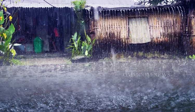
Bhubaneswar: The regional office of the India Meteorological Department (IMD) on Sunday said that a cyclonic circulation lies over the Northeast Bay of Bengal and neighbourhood extending up to 5.8 km above mean sea level. Under its influence, a low-pressure area is likely to form over the northwest and adjoining west-central Bay of Bengal during the next 48 hours.
The current meteorological features indicate that fairly widespread to widespread light to moderate rainfall activity with isolated heavy to very heavy rainfall is very likely over Odisha during the next five days. Thunderstorms with lightning activity are also very likely during the next two days and it is advised to take safe shelter during thunderstorm activity to protect from lightning.
Details forecast and warning as follows:
Day 1: (Valid up to 0830 Hrs IST of 04.09.23)
Yellow warning (Be updated): Heavy to very heavy rainfall (7 to 20cm) is very likely to occur in isolated places over the districts of Angul, Dhenkanal, Kalahandi, Boudh, and Kandhamal. Heavy rainfall (7 to 11cm) is very likely to occur at isolated places over the districts of Balasore, Bhadrak, Jajpur, Keonjhar, Mayurbhanj, Cuttack, Sambalpur, Deogarh, Sonepur, Malkangiri, Koraput, and Nabarangpur.
Thunderstorm with lightning are very likely to occur at isolated places over the districts of of Balasore, Bhadrak, Jajpur, Kendrapara, Cuttack, Jagatsinghpur, Keonjhar, Mayurbhanj, Sundargarh, Jharsuguda, Sambalpur, Deogarh, Bargarh, Angul, Dhenakanl, Puri, Khurda, Nayagarh, Ganjam, Kandhamal, Boudh, Malkangiri, Koraput, Nawarangpur, Kalahandi, Raygada, and Sonepur.
Day 2: (Valid from 0830 Hrs IST of 04.09.2023 to 0830 Hrs IST of 05.09.2023.)
Yellow Warning (Be updated): Heavy to very heavy rainfall (7 to 20cm) is very likely to occur at isolated places over the districts of Koraput, Kalahandi, Malkangiri, and Nabarangpur. Heavy rainfall (7 to 11cm) is very likely to occur at isolated places over the districts of Khurdha, Puri, Cuttack, Dhenkanal, Keonjhar, Sambalpur, Angul, Sonepur, Boudh, Bargarh, Rayagada, Bolangir, Nuapada, Ganjam and Gajapati.
Thunderstorm with lightning is very likely to occur at isolated places over the districts of Balasore, Bhadrak, Jajpur, Kendrapara, Cuttack, Jagatsinghpur, Keonjhar, Mayurbhanj, Sundargarh, Jharsuguda, Sambalpur, Deogarh, Bargarh, Angul, Dhenkanal, Khurda, Puri, Nayagarh, Ganjam, Gajapati, Malakangiri, Koraput, Rayagada, Kandhamal, Kalahandi, Bolangir, Sonepur, and Boudh.
Day 3: (Valid from 0830 Hrs IST of 05.09.2023 to 0830 Hrs IST of 06.09.2023)
Yellow warning (Be updated): Heavy to very heavy rainfall (7 to 20cm) is very likely to occur at isolated places over the districts of Malakangiri, Koraput, and Nabarangpur. Heavy rainfall (7 to 11cm) is very likely to occur at isolated places over the districts of Gajapati, Ganjam, Rayagada, Nuapada, Kandhamal, Puri, Khordha, and Kalahandi.
Day 4: (Valid from 0830 Hrs IST of 06.09.2023 to 0830 Hrs IST of 07.09.2023)
Yellow warning (Be updated): Heavy rainfall (7 to 11cm) is very likely to occur at isolated places over the districts of Puri, Khordha, Nayagarh, Ganjam, Gajapati, Kandhamal, Kalahandi, Malkangiri, Rayagada, Koraput, Nawarangpur, Keonjhar and Mayurbhanj.
Day 5: (Valid from 0830 Hrs IST of 07.09.2023 to 0830 Hrs IST of 08.09.2023)
Yellow warning (Be updated): Heavy to very heavy rainfall (7 to 20cm) is very likely to occur at isolated places over the districts of Nuapada, Kalahandi, Bargarh, Bolangir, and Nabarangpur. Heavy rainfall (7 to 11cm) is very likely to occur at isolated places over the districts of Boudh, Sonepur, Koraput, Kandhamal, Rayagada, Gajapati, Ganjam, Sambalpur, Angul, and Nayagarh.


