


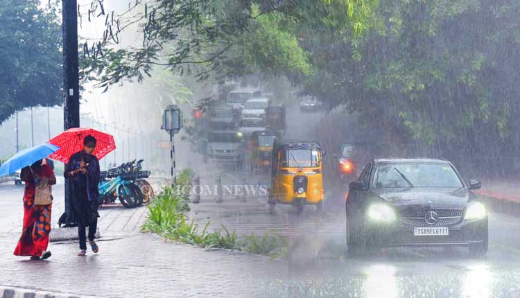
Bhubaneswar: The India Meteorological Department (IMD) has warned of intensifying weather conditions across Odisha, with a low-pressure area expected to form over the northwest and adjoining westcentral Bay of Bengal (BoB) around August 13.
This development comes amid reports of heavy to very heavy rainfall already lashing parts of the state, prompting orange and yellow alerts for several districts over the coming days.
In its midday bulletin issued at 2.00 PM, the IMD’s Meteorological Centre in Bhubaneswar highlighted recent rainfall patterns.
Light to moderate rain occurred at a few places in Odisha, while heavy to very heavy downpours were recorded at isolated spots in Keonjhar, Kandhamal, and Balasore districts. Notable rainfall amounts included 15 cm at Daitari (Keonjhar), 9 cm at Tikabali (Kandhamal), and 8 cm at Jaipur (Balasore). Other areas like Phiringia (Kandhamal) and Jujumura (Sambalpur) saw 6 cm each. The bulletin noted that Nayagarh recorded the highest maximum temperature of 37.2°C, while Phulbani had the lowest minimum of 20.0°C in the state’s plains.
Looking ahead, the IMD forecasts light to moderate rain or thundershowers at varying intensities across Odisha districts for the next week. Key highlights from the seven-day outlook include:
Day 1 (up to August 12 morning): Light to moderate rain or thundershowers at a few places. Yellow warning for thunderstorms with lightning and gusty winds (30-40 kmph) in districts like Mayurbhanj, Keonjhar, Balasore, and others up to Malkangiri.
Day 2 (August 12-13): Rain at many places. Orange warning for heavy to very heavy rain, thunderstorms, and gusty winds in Koraput and Malkangiri. Yellow alerts for heavy rain in Nawarangpur, Kalahandi, and others, plus thunderstorms in coastal and northern districts.
Day 3 (August 13-14): Rain at most places. Orange alert persists for Malkangiri and Koraput, with yellow warnings for heavy rain in Nawarangpur, Nuapada, and thunderstorms statewide.
Day 4 (August 14-15): Rain at many places. Yellow warnings for heavy rain in Malkangiri, Koraput, Nawarangpur, and thunderstorms in coastal areas.
Day 5 (August 15-16): Rain at a few places. Yellow alerts for heavy rain in Nuapada, Nawarangpur, and thunderstorms in select districts.
Days 6-7 (August 16-18): Continued light to moderate rain at a few places, with no warnings.
The subsequent three days (August 18-21) are expected to see no large changes.
The bulletin outlined potential impacts in high-risk districts like Koraput and Malkangiri, including damage to plantations, structures, roads, and trees; waterlogging and flooding in low-lying areas; landslides; and disruptions to traffic, power, and transportation. Residents are advised to monitor weather updates, avoid travel, stay indoors during storms, unplug appliances, and steer clear of water bodies or conductive objects. Fishing operations should be suspended in disturbed areas, with ports and naval bases taking precautions.
Fishermen along the Odisha coast face escalating risks from Day 3 onward. Squally winds of 40-50 kmph gusting to 60 kmph are likely off south Odisha on August 13, extending statewide on August 14-15, with rough to very rough sea conditions. The IMD strongly advises against venturing into the sea during these periods.
As the low-pressure system evolves, authorities are on alert for possible escalation, with residents in vulnerable areas urged to prepare for action.


