Bhubaneswar: The City woke up to an intense spell of rains accompanied by lightning and thundershowers. Gusty winds during the wee hours of Saturday hampered communication, as the Capital residents were gearing up to celebrate Odisha’s 88th Foundation Day – Utkal Divas.
The intense phenomenon repeated itself in scattered spells, as the day progressed. Bhubaneswar, Cuttack, and many other parts of the State witnessed similar weather last (Friday) evening. According to Indian Meteorological Department (IMD), the system is very likely to continue over the next couple of days.
The clubbing of Westerly winds with a local disturbance has led to this condition – heavy and infrequent stormy downpours, during the onset of summer, the IMD informed.
Scientist at IMD Bhubaneswar, Umashankar Das said, “In lower and mid-atmosphere over Odisha, a discontinuity trough line has developed which is drawing in moisture from the Bay of Bengal. This system, combined with the Westerly disturbance is leading to spells of heavy to very heavy rains.”
The Westerly disturbance originates in the Mediterranean Sea and travels eastwards through Iran, Afghanistan, Pakistan, and northwest India. Though the westerlies cover a long distance, it carries moisture along the way from the Arabian Sea, before hitting Central India and Odisha, Das said.
Now, the Westerlies traverse in middle and upper tropospheric levels while the local disturbance over Odisha is a lower and mid-atmosphere phenomenon (as stated above). However, the system intensifies when these two intersect (now over Odisha).

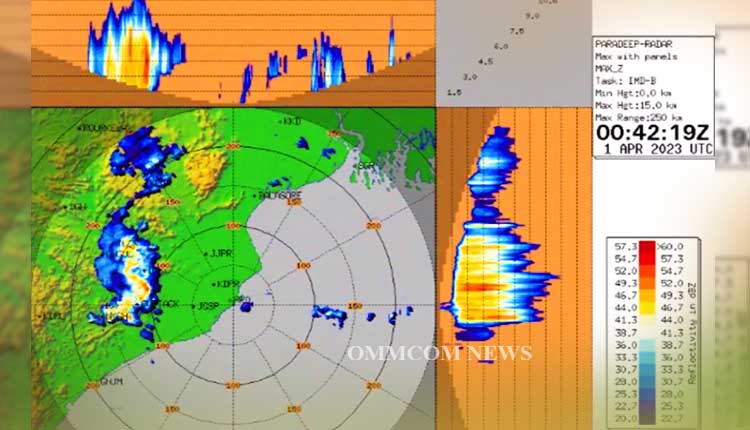
“The squall line, radar images above shows a cloud band covering 200 to 300 km area over the State. So, all these parts will have similar weather – with heavy to very heavy rains with lightning and gusty winds,” Das added.
On the other hand, Odisha is expecting a fresh western disturbance which is likely to hit the State on Sunday (April 2). As a result, several places in the state are likely to witness thunderstorms, lightning and gusty wind, the IMD informed.
However, reports stated that the fresh disturbance ingressing tomorrow is very likely to be on a higher latitude, so the intensity of the rain or thunderstorm would taper down.


