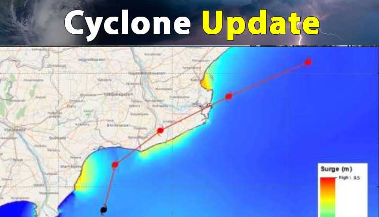
Bhubaneswar: The Cyclonic Storm ‘Asani’ over Westcentral Bay of Bengal is likely to cause maximum damage in some regions of Andhra Pradesh, stated the India Meteorological Department (IMD) on Wednesday.
Thatched huts, power and communication lines, both kutcha and pucca roads, paddy, and other standing crops may be damaged and low-lying areas are likely to be inundated in Krishna, East & West Godavari, Yanam in the Union Territory of Puducherry, and Vishakhapatnam in Andhra Pradesh.
The IMD has suggested people to stay in safe places, check for traffic congestion on routes before leaving for a destination, follow traffic advisories, and avoid going to areas that are often facing water logging problems.
The cyclone lay centered at 0830 hours IST of today over westcentral Bay of Bengal about 40 km southeast of Machilipatnam (Andhra Pradesh), 140 km southwest of Kakinada (Andhra Pradesh), 280 km southwest of Visakhapatnam (Andhra Pradesh), 520 km southwest of Gopalpur (Odisha) and 630 km southwest of Puri (Odisha).
It is very likely to move north-northeastwards along Narsapur, Yanam, Kakinada, Tuni & Visakhapatnam coasts till the evening of today and emerge into westcentral Bay of Bengal off North Andhra Pradesh coasts by today night. It is likely to weaken further into a depression by the morning of May 12.
Under its influence, light to moderate rainfall at most places with heavy to very heavy rainfall at a few places with isolated extremely heavy falls is likely over coastal Andhra Pradesh and heavy rainfall at isolated places is likely today over south coastal Odisha.
On May 12, light to moderate rainfall likely at many places with heavy rainfall at isolated places is likely over north coastal Andhra Pradesh, coastal areas of Odisha, and West Bengal.
Gale wind speed reaching 70-80 kmph gusting to 90 kmph is likely to prevail along & off
Krishna, East & West Godavari, Yanam of Puducherry UT and Visakhapatnam districts and 50-60 kmph gusting to 70 kmph along & off adjoining districts of Coastal Andhra Pradesh during forenoon to afternoon of today.
It would then decrease gradually to 45-55 Kmph gusting to 65 Kmph over the same region by the morning of May 12.


