





Bhubaneswar: The National Informatics Centre (NIC), Odisha, organised a Tech Boot Camp on “Empowering e-Governance through GIS – Remote Sensing & GeoAI” recently, with the objective of showcasing the transformative potential of geospatial technologies in strengthening e-Governance and enabling informed, data-driven decision-making.
The boot camp witnessed the participation of around 100 officials from various departments of the Government of Odisha and NIC Odisha State Centre.
The programme commenced with the auspicious lighting of the ceremonial lamp, followed by the welcome address by Dr. Ashok Kumar Hota, DDG & State Informatics Officer (SIO), Odisha.
He extended a warm welcome to the distinguished guests, eminent speakers and participants. In his address, he provided an introduction to the fundamentals of Remote Sensing and explained the concept of the Sun’s spectral signature, setting the context for the technical deliberations that followed.
In his inaugural address, the esteemed guest, Dr. Biswabijoyee Panigrahi, IRS (Retd.), Co-Founder & CEO of The DF Group and Chief Mentor of Trident Group of Institutions shared insights from his professional journey and highlighted advancements in emerging technologies, including LAM technology, simulators and chip fabrication.
He emphasised the need to sensitise government officials to technological advancements and their practical applications. He also highlighted the significance of NISAR (NASA-ISRO Synthetic Aperture Radar), elaborating on the potential of large volumes of satellite data and how their integration with GIS can enhance analytical capabilities, strengthen Decision Support Systems and facilitate informed decision-making in governance.
Delivering the keynote address, the esteemed guest, Karthick V., IFS, CF (ME&IV), Head – IT & GIS Wing, CE SMPB, PD WFP-OBDA, O/o PCCF & HoFF, shared practical case studies from his professional experience as an IFS officer, highlighting the significant role of GIS and Remote Sensing in forest management. He elaborated on the application of the Forest Fire Planner, emphasising the integration of geospatial data into Decision Support Systems for effective planning and timely interventions. He also discussed the capabilities of Google Earth Engine and underscored the growing significance of geospatial intelligence in strengthening governance, concluding that geospatial intelligence will play a pivotal role in shaping the next era of technology-driven decision-making.
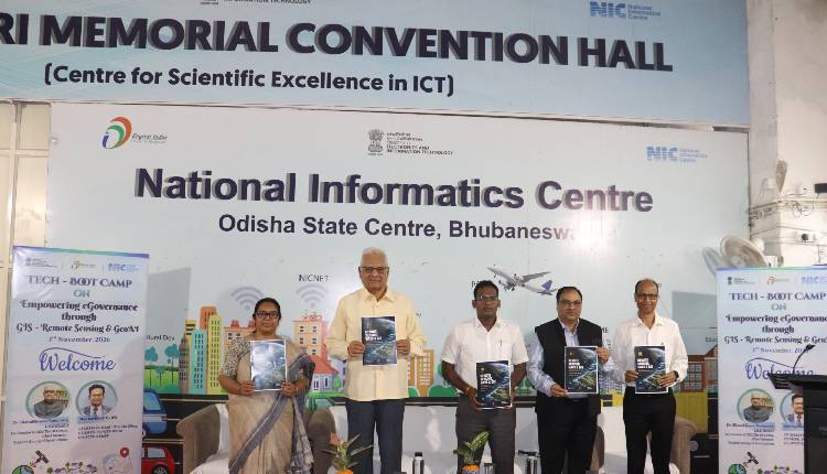
A brochure titled ‘REMOTE SENSING, UAVS & GIS’ was released, along with the November 2026 edition of NIC Odisha’s monthly newsletter, The Ascender, by the dignitaries.
The technical sessions featured a series of expert-led presentations covering key aspects of geospatial technologies and their applications in governance. Dr Vijay Veer, Head, Geo-Spatial Technology & Services Division, NIC Headquarters, New Delhi, delivered a session on Bharat Maps. Subhadarshi Mishra, Founder & CEO, SPARC INDIA, spoke on Turning Geospatial Data into Actionable Intelligence.
Jayanta Kumar Mishra, Scientist-F (Retd.), NIC, presented on Geo-AI in Governance, while Shri Goutam Behera, Business Analyst, BISAG-N, delivered a session on PM GatiShakti. The technical deliberations also included a session on Remote Sensing by Niladri B. Mohanty, Scientist-D, NIC, and Ravinder Choudhary, Scientific Officer, NIC.
These sessions provided participants with insights into emerging geospatial technologies, their practical applications and their potential to enhance evidence-based planning and governance.
Shiwani Korah, Sr. Director (IT) & Head, Training Division, delivered the vote of thanks, expressing her sincere appreciation to the resource persons, coordinators and participants for their valuable contributions towards the successful conduct of the boot camp. Participation certificates were subsequently presented to all the participants in recognition of their active involvement. The programme concluded on a positive note, providing participants with valuable insights into the applications and potential of GIS, Remote Sensing and GeoAI in advancing e-Governance and strengthening data-driven decision-making.