


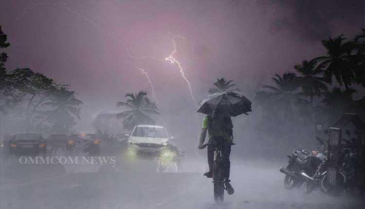
Bhubaneswar: The India Meteorological Department (IMD) on Tuesday issued a ‘Yellow’ warning for light rain or thundershowers, which are very likely to occur in various parts of Odisha until April 11.
According to the IMD’s mid-day weather bulletin, light rain or thundershowers are very likely to occur in the afternoon or evening hours at one or two places in the following districts, Balasore, Bhadrak, Jajpur, Kendrapara, Cuttack, Jagatsinghpur, Puri, Khurda, Nayagarh, Ganjam, Gajapati, Mayurbhanj, Keonjhar, Sundargarh, Rayagada, Koraput, Angul, and Dhenkanal. Dry weather is expected to prevail over the remaining districts of the state on April 9.
The IMD also issued a ‘Yellow’ warning for thunderstorms with lightning, which are likely to occur in the afternoon or evening hours at one or two places in the same districts mentioned above.
On April 9 and 10, the IMD predicted light rain or thundershowers in the afternoon/evening hours at one or two places in the districts of Balasore, Bhadrak, Jajpur, Kendrapara, Cuttack, Jagatsinghpur, Puri, Khurda, Nayagarh, Ganjam, Gajapati, Mayurbhanj, Keonjhar, Sundargarh, Rayagada, Koraput, Malkangiri, and Nabarangpur. Dry weather is expected to prevail in other districts.
Additionally, a ‘Yellow’ warning has been issued for thunderstorms with lightning and gusty winds reaching speeds of 30-40 km/h likely to occur in the afternoon/evening hours at one or two places in these districts.
On April 10 and 11, the IMD predicted light to moderate rain or thundershowers at a few places in the districts of Balasore, Bhadrak, Jajpur, Kendrapara, Cuttack, Jagatsinghpur, Puri, Khurda, Nayagarh, Ganjam, Gajapati, Mayurbhanj, Keonjhar, Sundargarh, Angul, and Dhenkanal.
The IMD also issued a warning for thunderstorms with lightning and gusty surface winds reaching 40-50 km/h which are very likely to occur in the afternoon/evening hours at a few places in these districts.
Thunderstorms with lightning and gusty winds reaching speeds of 30-40 km/h are also expected in the districts of Koraput, Malkangiri, Nabarangpur, Kalahandi, Rayagada, and Nuapada.
The IMD further stated that light to moderate rain or thundershowers are very likely to occur at one or two places in the districts of Balasore, Bhadrak, Jajpur, Kendrapara, Cuttack, Jagatsinghpur, Puri, Khurda, Nayagarh, Ganjam, Gajapati, Mayurbhanj, Keonjhar, Kandhamal, Rayagada, Koraput, and Malkangiri from April 12 to 14. Dry weather is expected to prevail in the remaining districts.
The IMD also reported that a Low-Pressure Area over the southwest and adjoining southeast Bay of Bengal has moved northwestwards and is now a Well-Marked Low-Pressure Area over the southwest and adjoining West-Central Bay of Bengal as of 8:30 am on April 8, 2025.
The associated cyclonic circulation extends up to middle tropospheric levels. It is likely to move north-northwestwards over the next 24 hours, maintaining its intensity as a well-marked low-pressure area.
The system is expected to recurve north-northeastwards and gradually weaken over the central Bay of Bengal during the subsequent 24 hours.
Regarding the temperature, the IMD has predicted a fall of 2-3°C in the maximum temperature (day temperature) over the next three days, with a rise of 2-4°C thereafter. The maximum temperature is expected to be at or above 40°C in isolated pockets of the districts of Jharsuguda, Sambalpur, Sundargarh, Bolangir, Sonepur, and Titlagarh.


