


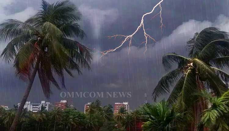
Bhubaneswar: The India Meteorological Department (IMD) has issued a Yellow Warning (Be Aware) for thunderstorm accompanied by lightning and gusty surface winds over several coastal and interior districts of Odisha for the next two days, even as light to moderate rainfall and heavy showers lashed parts of North Coastal Odisha on Wednesday.
According to the Midday Weather Bulletin issued at 1430 hrs IST by the Meteorological Centre Bhubaneswar, an upper air cyclonic circulation over Odisha at 0.9 km above mean sea level persists, along with a north-south trough extending to the Gulf of Mannar. This system is expected to trigger thundery activity across the state in the immediate term.
Day-1 (valid till 0830 hrs IST of April 10): Light to moderate rain or thunderstorm is very likely at one or two places over Mayurbhanj, Keonjhar, Balasore, Bhadrak, Jajpur, Kendrapara, Cuttack, Jagatsinghpur, Puri, Khurda, Nayagarh, Ganjam, Gajapati, Angul, Dhenkanal, Boudh, Kandhamal, Rayagada, Koraput and Malkangiri districts. Dry weather is likely elsewhere.
Yellow Warning: Thunderstorm with lightning and gusty winds (40–50 kmph) very likely at one or two places over Bhadrak, Jagatsinghpur and Kendrapara.
Thunderstorm with lightning and gusty winds (30–40 kmph) very likely at one or two places over Mayurbhanj, Keonjhar, Balasore, Jajpur, Cuttack, Puri, Khurda, Nayagarh, Ganjam, Gajapati, Angul, Dhenkanal, Boudh, Kandhamal, Rayagada, Koraput and Malkangiri.
Day-2 (April 10–11): Similar rain/thunderstorm activity is very likely over Balasore, Bhadrak, Jajpur, Kendrapara, Cuttack, Jagatsinghpur, Puri, Khurda, Nayagarh, Ganjam and Gajapati districts, with the 30–40 kmph gusty wind and lightning warning continuing in these areas. Dry weather elsewhere.
From Day-3 to Day-7, dry weather is forecast across Odisha, though hot and humid conditions are likely in isolated pockets over the coastal districts.
Yesterday’s rainfall saw heavy showers at one or two places in Cuttack and Balasore districts of North Coastal Odisha. The chief amounts (in cm) were: Khaira (Balasore) 9, Banki (Cuttack) 7, Garadapur (Kendrapara) 6, Ghasipura (Keonjhar) 5, Ranpur (Nayagarh) 5 and several others between 3–4 cm. As per news reports, one person died in Puri district after being struck by lightning during a thunderstorm on April 8.
Maximum temperatures recorded an appreciable fall of about 3°C in North Coastal and North Interior Odisha and remained markedly below normal (6–8°C) in several coastal areas. The highest maximum was 39.5°C at Titilagarh. Minimum temperatures were also below normal in many places. No large change in day temperatures is expected for the next two days, followed by a gradual rise of 4–6°C.
For Bhubaneswar and neighbourhood, partly cloudy sky with possibility of rain or thunderstorm is forecast for the next 24 hours. Maximum and minimum temperatures are likely to hover around 35°C and 23°C respectively. Observations at 0830 hrs IST today: Maximum 34.8°C, Minimum 22.8°C, Relative Humidity 93/57%, Rainfall 11.2 mm.
Fishermen Warning (Day-1): Squally weather with wind speed reaching 40–50 kmph, gusting to 60 kmph, is very likely along and off the Odisha coast on April 9. Sea conditions will be rough to very rough. Fishermen have been advised not to venture into the sea on April 9. No warnings for Days 2–5.
The IMD has urged citizens to remain alert, especially in the afternoon and evening hours.


