


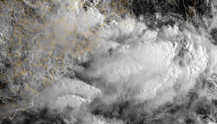
Bhubaneswar: Under the influence of the cyclonic circulation, a low-pressure area has developed over the northwest Bay of Bengal and adjoining West Bengal and Bangladesh coasts, triggering concerns of heavy rainfall in Odisha and eastern states.
The India Meteorological Department (IMD) scientist , Umashankar Dash informed that the low-pressure area has formed over the northwest Bay of Bengal and adjoining West Bengal and Bangladesh coasts this morning. It is likely to move slowly west-northwestwards through North Odisha, West Bengal and Jharkhand for the next two days.
ସୃଷ୍ଟି ହେଲା #ଲଘୁଚାପ କ୍ଷେତ୍ର
ଗତ କାଲିର ଘୂର୍ଣ୍ଣିବଳୟ ପ୍ରଭାବରେ ଆଜି ସକାଳ ସମୟରେ ଉତ୍ତରପଶ୍ଚିମ ବଙ୍ଗୋପସାଗର ପାର୍ଶ୍ଵବର୍ତ୍ତୀ ପଶ୍ଚିମବଙ୍ଗ ଏବଂ ବାଂଲାଦେଶ ଉପକୂଳରେ, ଏକ #ଲଘୁଚାପ କ୍ଷେତ୍ର ସୃଷ୍ଟି ହୋଇଛି l ଏହା ଆଗାମୀ 2ଦିନ ଯାଏଁ ଧିରେ ଧିରେ ପଶ୍ଚିମ-ଉତ୍ତରପଶ୍ଚିମ ଦିଗରେ ଉତ୍ତର ଓଡିଶା, ପଶ୍ଚିମବଙ୍ଗ pic.twitter.com/ZOAzQD271E
— usd (@usd0705) June 29, 2025
Heavy rainfall is expected at isolated places in several districts of Odisha.
Several parts of Odisha experienced heavy rainfall. Bhubaneswar and Cuttack cities have been issued an orange alert, indicating heavy rainfall.
Rough to very rough sea conditions are expected during this period, prompting fishermen to be advised against venturing into the sea.
The low-pressure system is expected to bring heavy to very heavy rainfall to parts of Odisha and neighbouring regions over the next few days.


