


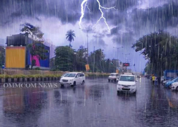
Bhubaneswar: The India Meteorological Department (IMD) issued a series of Yellow Warnings for multiple districts of Odisha on Thursday, forecasting a mix of thunderstorm activity accompanied by gusty winds alongside persistent heatwave and hot, humid conditions over the next five days.
According to the Midday Bulletin issued by the Meteorological Centre Bhubaneswar, a trough runs from a cyclonic circulation over northeast Bangladesh to north interior Odisha across Gangetic West Bengal and southeast Jharkhand at 0.9 km above mean sea level. This system is likely to trigger light to moderate rainfall and thunderstorm activity in several pockets, particularly in the southern and coastal belts of the state.
The weather office has warned of thunderstorms accompanied by lightning and gusty surface winds reaching speeds of 30-40 kmph. These conditions are expected during the afternoon and evening hours over districts including Mayurbhanj, Keonjhar, Balasore, Ganjam, Gajapati, Koraput, Malkangiri, Nawarangpur, Rayagada, and Kandhamal over the next 24 hours (Day 1).
The intensity of surface winds is expected to rise to 40-50 kmph from Day 4 (April 26) onwards over southern and western Odisha districts such as Gajapati, Ganjam, Koraput, Malkangiri, Rayagada, Kandhamal, and extending to northern parts like Mayurbhanj, Keonjhar, and Sundergarh by Day 5 and Day 6.
“Heat wave conditions are very likely to prevail at isolated places over the districts of Bolangir, Jharsuguda, Sambalpur, Keonjhar, and Khordha,” the bulletin stated for Day 1, noting that Angul would also come under the heatwave watch from Day 2.
Alongside the dry heat, coastal Odisha is reeling under uncomfortable conditions. The IMD has forecast hot and humid conditions at isolated places over a vast stretch of districts including Keonjhar, Mayurbhanj, Balasore, Bhadrak, Jajpur, Kendrapara, Cuttack, Jagatsinghpur, Puri, Khurda, Nayagarh, Ganjam, and Gajapati.
Additionally, the bulletin flagged “warm night” conditions for Bolangir, Sambalpur, and Kandhamal on Day 2 and Day 3, indicating that minimum temperatures are likely to remain significantly above normal, offering little respite after sunset.
The mercury has seen an appreciable rise across Coastal Odisha, with maximum temperatures climbing by 3 to 4 degrees Celsius at one or two places. Maximum temperatures across the state are currently running 2 to 3 degrees Celsius above normal.
The bulletin noted that light to moderate rainfall was observed at a few places in South Interior Odisha with Kotpad (Koraput) recording 3 cm of rainfall and Padia (Malkangiri) recording 1 cm.
The Farmers Weather Bulletin advises agricultural operations to account for the likely thunderstorm and lightning activity in the warned districts.
Looking ahead, IMD forecasts light to moderate rain at one or two places over the next 24 hours for the capital city, Bhubaneswar, and its neighbourhood. The outlook for the subsequent three days indicates no large change in the overall pattern.


